Tornado outbreak and flash floods gripping the Midwest: Days of devastation await
By willowt // 2025-04-03
Tweet
Share
Copy

- A series of powerful tornadoes struck six Midwest states (Arkansas, Missouri, Michigan, Oklahoma, Tennessee and Indiana), causing severe damage, power outages for 375,000+ residents and life-threatening conditions. Arkansas was hardest hit, with three tornadoes prompting a rare NWS "tornado emergency" warning.
- Arkansas experienced the worst destruction, including flipped vehicles, demolished homes and debris lifted 25,000 feet into the air. Blytheville and Lake City suffered significant damage, with highways closed and emergency rescues underway.
- Even as tornadoes subsided, the NWS warned of historic flash flooding in Tennessee, the Ohio Valley and Mississippi Valley, with rainfall potentially exceeding a foot. Officials emphasized the unprecedented, life-threatening nature of the storms.
- Arkansas Governor Sarah Huckabee Sanders allocated $250,000 for disaster recovery and deployed National Guard teams. Rescues occurred in Indiana (trapped warehouse worker) and Kentucky (four injured, one critical after a tornado struck their car).
- The storms highlight the need for climate adaptation, with extreme weather events becoming more frequent and intense. Recovery efforts continue as the region braces for additional severe thunderstorms through the weekend.
The Midwest's calamitous tornado outbreak
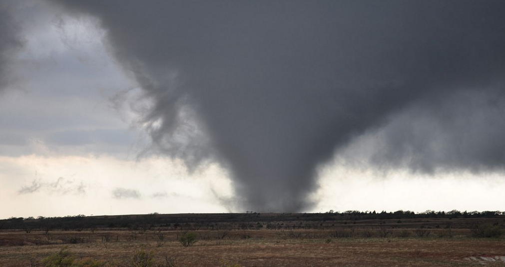
Beginning in the late afternoon, a string of tornadoes swept through Missouri, Michigan, Arkansas, Oklahoma, Tennessee and Indiana. Eyewitnesses and social media videos captured the full force of the storms as massive tornadoes tore across fields and cities, flipping vehicles, destroying buildings and uprooting trees. In Arkansas, meteorologist Chelly Amin described the scene as "horribly devastating," noting that debris from the storms was lifted as high as 25,000 feet into the air, a testament to the ferocity of the twisters. "The sun is setting here, so now this turns into a much more dangerous situation, trying to track the severe weather as the daylight goes away," AccuWeather reporter Leslie Hudson warned, highlighting the ongoing menace of the storms even after they initially calmed.Arkansas: Ground zero of the tornadoes
Arkansas bore the brunt of the tornadoes, with three separate touchdowns recorded in different counties. In Craighead County, multiple homes were damaged, and emergency responders assisted two people trapped in a home. Tragically, one person was left in critical condition in Kentucky, although no fatalities were reported in Arkansas. At the height of the storm, the NWS issued a tornado emergency for the region, its highest level of alert. The service stressed the urgency for residents to seek shelter immediately. "This is a life-threatening situation. Seek shelter now," the NWS warned on X. The city of Blytheville was particularly hard-hit, with two miles of Highway 18 temporarily closed due to a downed power line. Nearby Lake City faced unspecified, but extensive, damage, including severe structural damage and significant debris.Mobilizing for recovery and flash floods
Even as the immediate danger of the tornadoes subsided, officials and experts scrambled to prepare for the next round of storms. The National Weather Service (NWS) forecasted a perilous situation with significant flash flooding expected over the coming days. Middle Tennessee and parts of the lower Mississippi Valley and Ohio Valley are bracing for heavy rainfall that could exceed a foot in many areas. "This is an event that happens once in a generation to once in a lifetime," noted NWS meteorologist Mark Rose. He warned that "historic rainfall totals and impacts are possible," stating that the current front is not moving, thereby compounding the threat of prolonged flooding. To assist in the recovery efforts, Governor Sarah Huckabee Sanders of Arkansas signed an executive order to provide $250,000 from the Governor's Disaster Response and Recovery Fund. She also mobilized four high-water teams and more than 40 Arkansas National Guardsmen to assist in evacuating flooded areas.Immediate rescues and evacuations
Local authorities in Indiana and Kentucky, with assistance from emergency medical services, rescued and treated victims of the storms. In Brownsburg, Indiana, a partially collapsed warehouse left one person trapped. Adjoining crew reports and paramedics worked diligently to extricate the individual, who remained awake and alert throughout the rescue. Nearby, a radio tower was toppled, contributing to the disruption and danger for surrounding residents. In Kentucky, four people were injured, one critically, after taking shelter in a car during a direct hit by the tornado. Emergency services responded quickly, transporting injured individuals to local hospitals.Conclusion
As the Midwest braces for an extended period of severe weather, the unprecedented intensity of these storms underscores the growing urgency of climate adaptation and resilience. With ongoing severe thunderstorms forecasted through Saturday, residents and emergency services will need to remain vigilant. The current weather event, rare in its magnitude, serves as a stark reminder of the increasing frequency and intensity of extreme weather events. As national and local leaders work to support recovery efforts, the resilience of communities in the face of such challenges will be tested. Sources include: DailyMail.com NewsBreak.com CNN.comTweet
Share
Copy
Tagged Under:
collapse environment national security disaster big government SHTF panic chaos ecology electricity tornado dangerous climate flooding midwest evacuations weather terrorism severe weather
You Might Also Like
By Finn Heartley // Share
Israel kills Hamas commander in Lebanon, escalating tensions amid fragile ceasefire
By Cassie B. // Share
Israeli strikes kill over 100 Palestinians in a single day as Israel divides up Gaza
By Cassie B. // Share
New natural gas-powered AI data center unveiled in Pennsylvania
By Willow Tohi // Share
Oracle faces backlash over data breaches that have exposed millions of customer records
By Willow Tohi // Share
Recent News
Amazon’s last-minute TikTok bid faces skepticism as Trump’s deadline looms
By isabelle // Share
Israel kills Hamas commander in Lebanon, escalating tensions amid fragile ceasefire
By isabelle // Share
Microsoft scales back AI data center boom as China’s DeepSeek upends the market
By isabelle // Share


